- natural indicators
- Why is the water level dropping?
- Seasonal "loss" of water
- The emergence of "healthy competition"
- Building settlement
- Tectonic shifts
- Alternative search methods
- How to find a source of water
- Where can you dig wells
- Location of aquifers in the ground
- Folk ways to determine the aquifer
- Orientation by natural features
- With the help of dowsing frames
- Observation in search
- Observation #1 - summer mists
- Observation #2 - Animal Behavior
- Observation #3 - Species of Growing Plants
- Observation #4 - Help from Friends and Neighbors
- Search Practices
- Method # 1 - using glass containers
- Method # 2 - the use of hygroscopic material
- Search for water by observation
- Fog
- Animals
- Plants
- Effective ways to find water
- Types and functions of aquifers of the earth
- Effective ways to find water
- barometric method
- Exploration drilling
- Seismic exploration method
- Electrical sounding method
natural indicators
Groundwater close to the surface can be determined quite accurately by observing natural phenomena, the behavior of domestic animals, or plants growing on the site. It is possible to determine the depth of water occurrence even by the surrounding landscape. There will almost certainly be water in natural depressions and pits.And on the slopes or on the hills dominating the surroundings close to the surface, finding water is problematic.
If there is thick fog on the site in the evenings, then there is water in this place.
Sometimes, in order to determine where the water is closest to the surface of the soil, it is enough just to carefully observe your site. If there is a place on it where in the evening after a hot day or in the morning, before sunrise, thick fog constantly swirls or stands in a column, then it is in this place that it is worth digging a well or drilling a well: the water here is definitely not far from the surface, and there will be a lot of it.
Many animals and insects feel the proximity of water. If you find a dwelling of red ants on your site, you can be sure that there is no water nearby. But clouds of midges or mosquitoes constantly curling over one place indicate the opposite: water is somewhere nearby.
Also, some plants can act as indicators of the proximity of water. Sedge, reeds, coltsfoot usually grow only in those places where the water is no more than 2-3 m. root and does not usually grow in wetlands.
Why is the water level dropping?
To answer the question of how to raise the water level in the well, you need to find the main cause of the trouble. Natural or constructive factors can provoke an insufficient amount of fluid.
Natural causes:
- seasonal fluctuations in water levels: for example, dry summers;
- the channel that the underground river has changed;
- soil composition: its subsidence.
Design factors:
- defects (the first is depressurization of joints);
- mistakes made during construction;
- siltation of the bottom of the well;
- slippage of rings.
Now we need to consider the causes that occur most often.
Seasonal "loss" of water
As a rule, in those sources that were dug up to the first water horizon, there is always a seasonal shortage of filling. The water level drops at the end of summer, in winter. The reason is the long absence of precipitation. To check the guess, at the same time excluding other options, it is better to ask how the neighbors are doing.
Seasonal deficiency cannot be corrected. We have to wait for the torrential rains. In order not to encounter such problems, it is not recommended to build a well at a time when the water level is high - in spring or autumn. Then there is a chance not to "get acquainted" with the water shortage.
The emergence of "healthy competition"
The construction of a powerful well in the neighborhood is another event that causes the water level in the source to drop significantly. In this case, a large water intake by a new, productive design causes a strong "impoverishment" of all shallow wells nearby.
In the latter case, there is an opportunity to correct the situation - to dig a well. However, you first need to talk to your neighbors to make sure your conclusion is correct. But recovery does not always help. It often turns out that it is easier and cheaper to equip a new hydraulic structure than to try to revive the old one.
Building settlement
The drawdown of the lower ring happens due to the mistake of those who dug the well. If the lower element was installed too close to the aquifer, then after a certain period of time the structure is able to sag under its own weight.
Checking the guess - drilling the first ring with horizontal rows of holes, their pitch is 150-200 mm. The same operation is done at a distance of 1000-1500 mm from the lower perforation. If water does not appear after a while, then it can be argued that the well is exhausted.
Tectonic shifts
The departure of the underground river is another possible scenario. The culprits of the fall in the level are the movements of the earth's crust. They provoke a change in the direction of the underground flow. With full confidence, it will not be possible to “diagnose” this problem, since the process is not visible to the eye. But this reason can be suspected if there are no other warning signs.
Alternative search methods
Often to find water and place on the lot under the well, use various non-contact search methods that do not allow spoiling the terrain.
For example, you can use balls made of silica gel. They absorb moisture, so they are ideal for searching.

The technology can be done correctly in the following way:
- First, fry the balls in the oven;
- After that, they are divided into equal portions and placed in tissue nodules;
- Further, such nodules need to be buried in the area in those places where the well is supposed to be erected;
- When the day has passed, the bags can be dug up and weighed (for simplicity, you can weigh them up to clearly see the difference).
It is clear that the heaviest portion will indicate where the most water is. This method is good for giving, where the measurement accuracy is not so important and you need to dig a small well.
To more accurately determine the place under the tank, there are other ways. For example, you can use a barometer.
After that, you can take measurements directly on the site, measuring the pressure level.
So, the water level is determined by the pressure difference in the terrain.
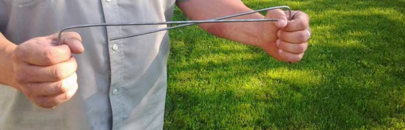
It is also realistic to find a place for a well on the site using the frame method.
It is enough to find two aluminum sticks about thirty centimeters long. They are bent at a right angle of about ninety degrees.


It will be correct to insert the metal ends into the wooden cavities, for example, using sticks or a vine without a core.
In order not to move the sticks on their own, the elbows are pressed tightly against the body, and the arms are held at a right angle. Both sticks are held in their hands and slowly walk around the site, trying not to make sudden movements.
So, if the vein underground is to your left, then the wire will turn in that direction. If to the right, then to the right. If you stand directly above the core, then the ends of the wires should connect.
Video:
How to find a source of water
For water consumers, raw materials from layers that are very deep (more than 15 m) are best suited. In such deposits, water is suitable for watering the garden and garden, washing, washing and other domestic purposes.
The following areas of land are likely to have problems finding water:
- not far from rivers, especially from the side of the steepest of the banks;
- in terrain with mountains and hills;
- close to quarries and large water intakes;
- near ponds and streams;
- not far from large clusters of acacia and beech.
 You can determine water by plants
In addition, on some land plots, water is not of good quality a priori. In such areas it is necessary to dig very deep wells or use only imported moisture.
You can find water on the site in different ways. Some methods are time-tested, they have been used for many centuries, while others have been developed recently.Before you start looking for water on the site, it is best to familiarize yourself with several methods, study their features, and determine for yourself the most suitable for a particular area and situation. To optimize the cost of energy and money for the search process and the subsequent development of the soil, it is possible to combine several methods at once.
Where can you dig wells
Before you look for water for a well on the site, you need to decide on the places where you can install the structure. We recommend that you familiarize yourself with the general rules for the location of wells in order to organize safe and convenient water production.
The drinking source should be at least 25 meters away from the epicenters of soil contamination, such as cesspools, landfills, sewers, street toilets. Otherwise, harmful substances and pathogenic bacteria can enter the well through the water-containing layers.

General scheme of a site with a well for drinking water
The well should be moved away from the buildings by 10-15 m to protect the buildings from flooding
At the same time, it is also necessary to pay attention to the objects of the neighboring site .. However, the standard summer cottage is 4 acres
At the same time, it is always densely planted and built up and there is a problem with compliance with the norms. In this case, you can move it to a distance of only 5-7 m from the house or outbuilding.
However, the standard suburban area is 4 acres. At the same time, it is always densely planted and built up and there is a problem with compliance with the norms. In this case, you can move it to a distance of only 5-7 m from the house or outbuilding.
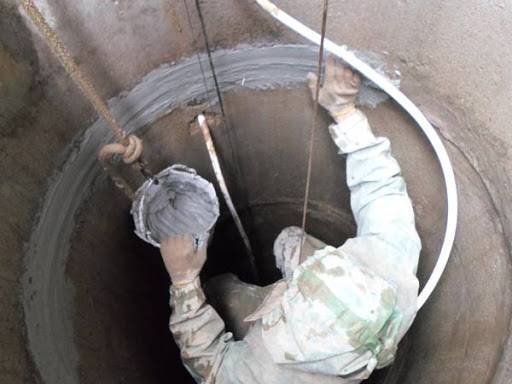
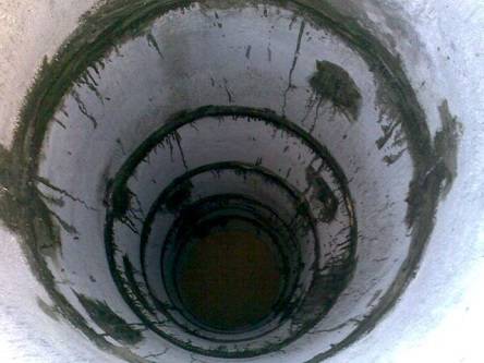
These rules apply to shaft-type wells.Deep wells require an even greater distance from buildings and contaminated areas.
For those who are wondering how to find a place for a drinking well, it is worth remembering that it is best to avoid:
- places subject to frequent flooding;
- wetlands;
- areas adjacent to highways.

According to this principle, wells of various depths can be placed.
If the soil in the area of the planned well is clayey, then the risk of flooding of the site is noticeably reduced. But at the same time, it is necessary to organize a thorough insulation of the walls of the structure. You can dig into the ground special frame rings made of asbestos. This will save water from pollution associated with snowmelt and precipitation.
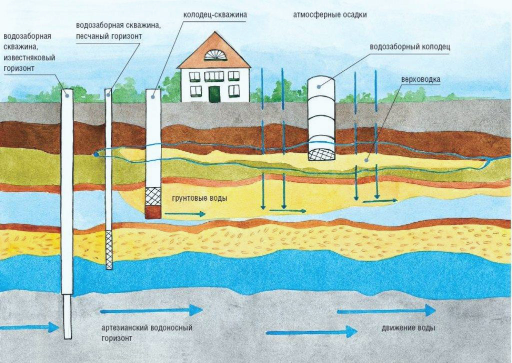
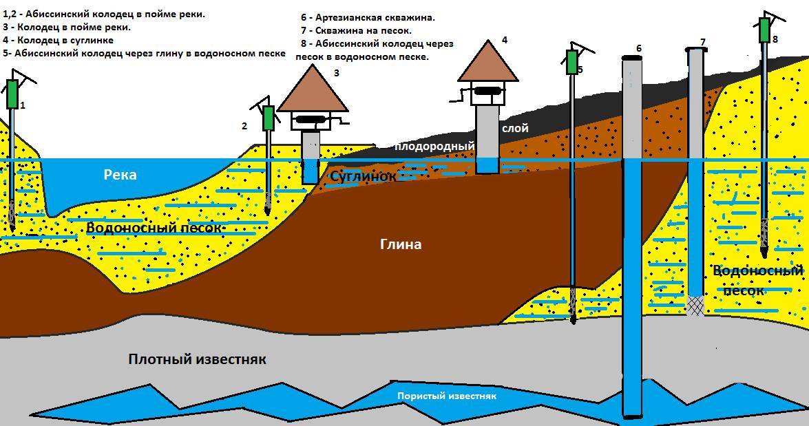
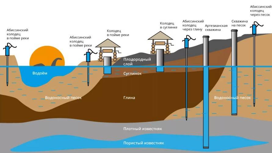
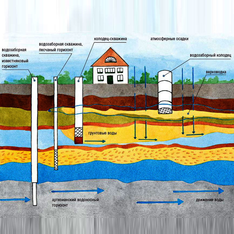
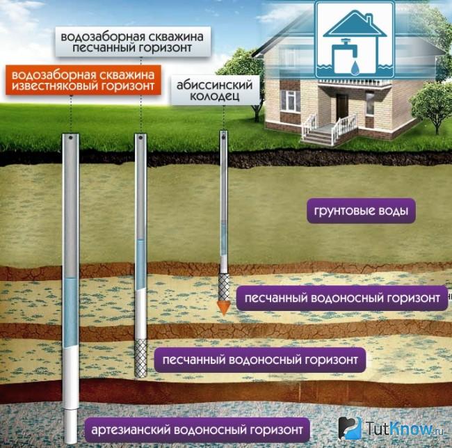
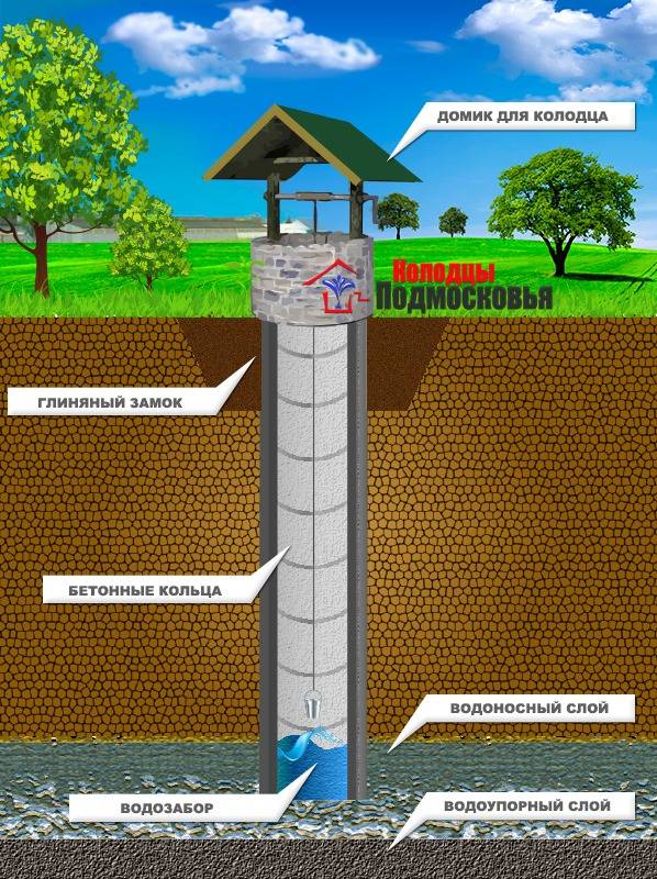
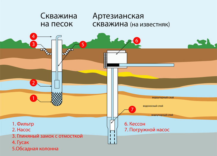
Location of aquifers in the ground
Water is retained in the soil due to water-resistant layers that do not allow the liquid medium to pass deeper or, conversely, to the surface of the earth. The main component of the layers is clay, which has a high degree of resistance to moisture, as well as stones.
Between the layers of clay and stones of different density is a sandy layer that holds clean water. This is the aquifer, which must be reached while digging a well structure. Therefore, before you get water, you need to have an idea about the aquifers.
In one place the sand layer can be thin, in another it can reach enormous sizes. In the place of a break in a water-resistant layer, which is not placed strictly horizontally, but has elevation changes, bends, the largest volume of water is collected.
In areas of clay curvature and changes in the height of the formation, peculiar breaks are formed, which are filled with wet sand. So much water collects in these zones that they are called "underground lakes".
But how to determine the depth of water? There is no exact answer. You can use a special map of the region, which indicates the approximate depth of the aquifer. However, it is only possible to accurately determine the location of the source during digging.
When digging a well or well, an aquifer can be found already 2-2.5 meters from ground level. But it is not recommended to use liquid from this aquifer. Water from the well should be suitable not only for irrigation and domestic needs, but also for drinking. Due to the proximity of the vein to the surface, untreated atmospheric precipitation, sewage and other wastes enter it.
Experts call such a layer - "top water". In addition, this layer is characterized by non-steel behavior. During the summer heat and drought, the source of moisture quickly disappears, and during the spring flood it often floods the land near the water. You can use such a liquid only for watering the garden and garden.
The optimal depth of the well for drinking water is 15 meters. Approximately at this distance from the soil surface there is a line of continental sands with a large supply of high-quality water. And the large thickness of the sand layer provides maximum cleaning of the liquid from all kinds of contaminants and "chemistry". If such a place is found, then this is a great success, but in practice the aquifer can be much deeper.


Folk ways to determine the aquifer
It is possible to carry out exploration on your own in search of an aquifer for drilling a shallow working or a well-needle, even if there are no landmarks in the adjacent areas.
Orientation by natural features
Signs of the presence of an aquifer in the soil can be:
- Observation of the behavior of animals and insects. Pillars of midges curl in the place where there is a source of water, and red ants, on the contrary, try to settle away from it.
- Wide distribution of moisture-loving plants in the area.
Nettle, horsetail, sedge, sorrel, reeds act as indicators of the proximity of groundwater from herbaceous plants. Tree-like plants with a taproot, such as bird cherry, willow, birch, black poplar, sarsazan, will indicate that the water lies at a depth of up to 7 meters.

On a hot afternoon, animals dig in the ground in search of coolness in places where groundwater is close to the surface.
For the soil, under the thickness of which the source passes, high humidity is characteristic. It will certainly evaporate, forming clouds of fog in the morning; you just have to keep an eye on the area.
Pay attention also to the relief. It is noticed that water carriers lie almost horizontally.
Therefore, in the region of depressions, the probability of occurrence of water is always higher.
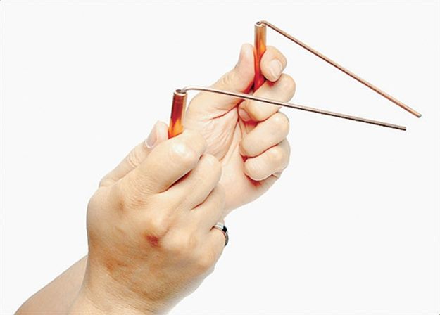
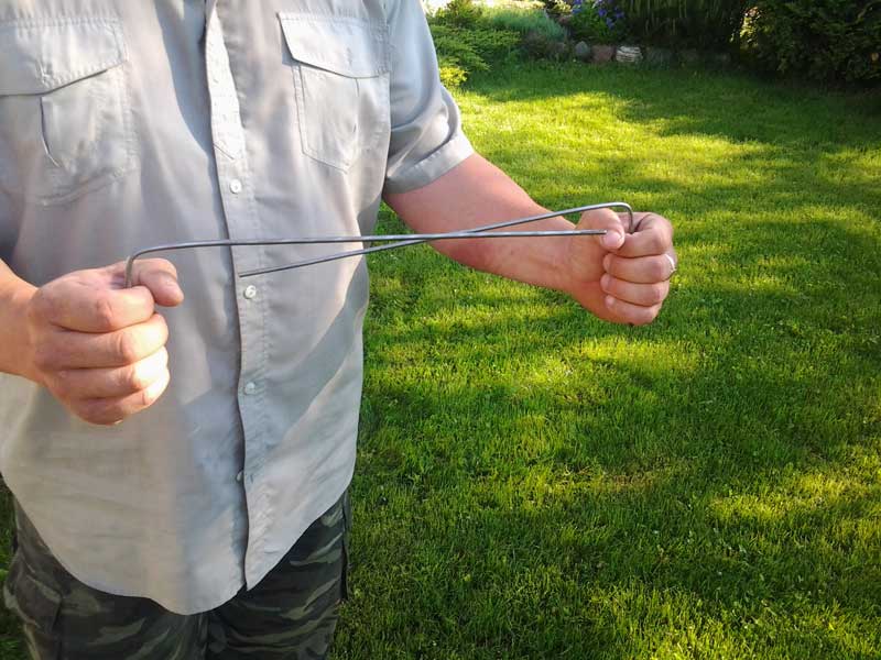
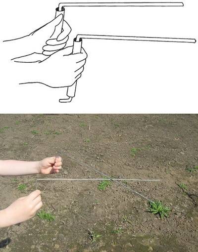
With the help of dowsing frames
The old method, based on the dowsing effect, in which a person reacts to the presence of water and other bodies in the earth, creating heterogeneities of various configurations and sizes in its thickness, does not lose popularity.
When searching for water in a site using a dowsing method, a wire frame or a tree branch with a fork in the hands of a human operator acts as an indicator. It is able to determine the presence of an aquifer, despite even the layer of soil separating from the water.
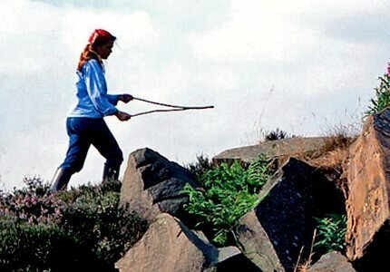
Dowsing - the ability of frames to move under the influence of external factors, for example, vibrate and approach each other above the places where the keys beat
Dowsing frames can be made of calibrated aluminum, steel or copper wire with a diameter of 2-5 mm. To do this, the ends of the wire segments 40-50 cm long are bent at a right angle, giving them an L-shape. The length of the sensitive shoulder will be 30-35 cm, and the handle 10-15 cm.
The task of the operator is to ensure the free rotation of the “tool”. To make it easier for yourself, wooden handles are put on the bent ends of the wire.
Bending your arms at a right angle and taking the tool by the wooden handles, you need to slightly tilt them away from you so that the wire rods become, as it were, an extension of the hands.
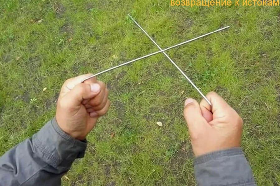
To achieve the goal, you need to consciously tune in and clearly formulate the task in front of you. After that, you just need to slowly move around the site and observe the rotation of the frames.
In the place of the site where groundwater is hidden, the rods of the frame will cross each other. The operator must mark this point and continue to explore, but already moving in a perpendicular direction relative to the original line of motion. The desired source will be located at the intersection point of the found marks.
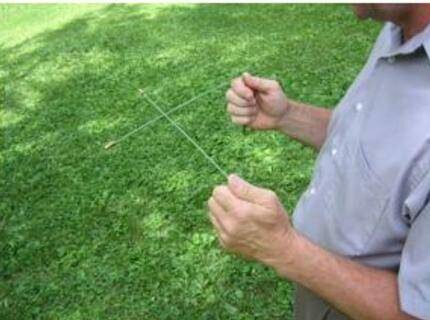
The dowsing frames will react by connecting the ends to each other in the place where the aquifers pass on the site
It is believed that the best time to search for water by dowsing is summer or early autumn. The most favorable periods:
- from 5 to 6 am;
- from 16 to 17 days;
- from 20 to 21 pm;
- from 24:00 to 1:00 am.
L-shaped frames are convenient to use in the field, but in the absence of wind. To work with the tool you need experience and skill. After all, the deviation of the frame can even depend on the emotional state of the operator.
For the same reason, before working with frames, it is better to refrain from drinking alcoholic beverages. Before you start searching, you need to learn how to work with a biolocator and “hear” it. Thanks to this, in the process of searching for water for a well, the operator will not be distracted even by the presence of closed water pipes on the site.
But it is worth noting that folk methods cannot give a 100% guarantee of obtaining the expected result. After all, even with a successful outcome, there is always a risk of getting a well with low productivity.
Observation in search
The ability to take note of everything and analyze the collected information has never been superfluous. It was in this way that our ancestors found water, who were not yet armed with the achievements of science and technology. What facts and phenomena of nature will help us in search of water?
Observation #1 - summer mists
Fog may appear on the site during the warm season. This natural phenomenon happens either in the early morning or in the late afternoon.
If you observe fog in your area, pay attention to its density: it will be highest in the place where the water is closest to the soil surface
If early in the morning you see fog in your garden, swirling or concentrated in one of its corners, then we can say with confidence that there is water in your area
The reason for the occurrence of such fog is the evaporation of water, which is underground. In one place, like ordinary fog, it will not stand. Moisture vapor can swirl or travel very low above the ground.


Observation #2 - Animal Behavior
Unlike humans, animals know exactly where the groundwater is. Too bad they can't tell us about it. Yes, they will not be able to tell, but please share your knowledge.
By observing the behavior of domestic and wild animals and birds, we can get all the necessary information:
- Dog. A dog is a man's friend and it will definitely help him in finding water for the well. In the heat, dogs are always looking for an opportunity to cool their body, so they dig holes where it is cooler. These are just the places we are looking for.
- Horse. When thirsty, the horse beats with its hoof in the place where there is water underground.
- Harvest mouse. But mice like where it's dry. They will never make their nests near places of high humidity. It is better to climb a tree or some building that rises above the soil level.
- Domestic bird. The chicken does not rush where it is wet, and the geese, on the contrary, choose the intersections of underground aquifers for their nests.
Even midges feel the proximity of water. If you look at its behavior at dusk, when the summer heat has already receded, then we will see columns of insects circling in the air exactly above those places where it is coolest - where underground there is what we need.
Dogs, like people, can hardly tolerate heat and drought. They try to get to the bottom of the coolest layers of soil, which are just above the aquifer.
In the place, involuntarily pointed out to us by representatives of the animal world, you can safely hit the Abyssinian well for extracting water for watering the garden and for taking care of the territory.
Observation #3 - Species of Growing Plants
Who should know about the presence or absence of water on the site, if not plants? Not surprisingly, they are used as indicators. If blackberries, buckthorn, lingonberries, bearberries, bird cherry, wood lice and wild rosemary feel good on your site, then it makes sense to look for an aquifer - it is always present.
Plants do not always like excess water. If there is too much of it, then they can even get sick and stop bearing fruit.
Take a closer look at the birch: its modest growth and knotty trunk with curvature betrays the presence of a nearby watercourse. Coniferous trees also prefer to grow where it is dry.
By the way, the presence of nearby groundwater is not always a boon for gardeners. After all, cherries and apples prefer moderate humidity: their waterlogging can provoke tree diseases and fruit rot.
Observation #4 - Help from Friends and Neighbors
If your site is part of a horticultural society or you have neighbors nearby, be sure to talk to them. As a rule, they have already solved the problems that you are struggling with today. If there is an operated well or well on their site, then you will also have water.
It is worth asking the neighbors at what depth the water in their source is, whether the level in it is stable. Thus, it is easiest and easiest to collect information and plan work on the device of the well. For private traders, polling the owners of adjacent sites is the only viable way to obtain hydrogeological data.
You always need to maintain friendly relations with neighbors: they will be the first to come to your aid, if something happens, they will protect your property from thieves
Try to find out not only the current state of the local water intake, but also the fluctuations in the water level throughout the year, as well as the composition of the water. Agree that it is not too pleasant to find your site flooded with flood waters in the spring. Get vital information in a timely manner.
Search Practices
When the observation stage is over, and the neighbor said that he had already bought the site with a well, it is time for a practical search for water layers using standard or non-standard methods.
Method # 1 - using glass containers
Finding the right amount of glass jars of the same size is not a problem for those who occasionally do home canning. If you don’t have cans, buy them, the summer resident will definitely need them sooner or later.
The contents of ordinary glass jars will eloquently tell you exactly where the aquifer can be located: look for a container with the highest concentration of condensate
Throughout the area, you need to dig glass jars of the same size with the bottom up to a depth of at least 5 cm. The duration of the experiment is a day. The next morning, before the sun rises, you can dig and turn the dishes.
We are interested in those banks in which there is condensate. It is more in banks located above aquifers.
Method # 2 - the use of hygroscopic material
It is known that salt is hygroscopic, that is, it is able to absorb moisture even from the air. The red brick crushed into powder has the same properties. Silica gel is another material that is perfect for our purposes.
To conduct the experiment, we will need several clay pots that are not glazed.Choose a day when there has not been rain for a long time and we expect that it will not be expected in the next day.
You need pots like this that are not covered with glaze inside and out, because they “breathe” perfectly and are able to pass water vapor inside
We fill the material into pots and weigh the resulting "devices". It is better to number the pots, and write down the data obtained. We wrap each pot with non-woven material and bury it at a depth of half a meter in the ground in different places of the site.
A day later, we unearth the bookmarks and re-weigh. The heavier the pot has become along with its contents, the closer to the place of its laying is the aquifer.
Search for water by observation
Many centuries ago, people knew how to find water for a well. To do this, you do not need to invite specialists and drill wells, it is enough to observe the surrounding nature and the behavior of animals.
Fog
In order to find a place for building a well in a country house or country house, inspect the territory of your land in the early summer morning or late evening. If the groundwater comes close to the surface of the earth, you will notice a gathering fog. In this case, the fog will not stand still. It rises in clubs and spreads above the ground surface.
The density of the fog cloud can be used to determine how deep the aquifer is. The thicker the consistency of the fog, the closer to the surface of the earth is the vein with water. Even if the fog is poorly visible in the evenings, in places where moisture evaporates from the ground, you can see a lot of midges, which stray and circle in a pile.
Animals
If there are closely spaced aquifers in the ground, field mice will not build burrows there.They will prefer to place them on tree branches or tall plants.
If you have a dog in the country, watch it in the heat. Usually in the very sun, in order to cool down a little, the animal begins to dig holes in the soil and fit into them. At the same time, they choose those places where an aquifer is located close to the surface of the earth. Moisture evaporating from underground contributes to the fact that the soil in these places is cooler. The same goes for horses. They beat their hooves in the heat in those places where water is close.


Plants
A place for a well can also be found by indicator plants. So, there are moisture-loving plants that will never grow in that part of the site where groundwater runs very deep. For example, hemlock, sorrel, coltsfoot, nettle, wild rosemary, lingonberry are very fond of moisture. If these plants have grown very much in your country house or country house, then you can be sure that there are aquifers nearby.
Trees can also tell us about the proximity of groundwater. For example, if willow, birch, bird cherry or alder grows very violently in your country house, then an aquifer passes nearby. In this case, often the crown of the tree leans precisely in the direction of the location of the vein. Cherry and apple trees do not like moist soil very much. In such places, these trees will often get sick, and their fruits may rot.
Pay attention to the landscape

Having studied the features of the relief on the site, it is also possible to draw conclusions about the place where the well was built. So, on the following types of landscape, you are unlikely to find enough water to build a well:
- if there are significant elevations;
- on a steep river bank;
- near wells, quarries or various water intake facilities;
- in places of active growth of pine and acacia.
For the water you find to be of high quality, do not look for it in the territory of drained swamps and low coastlines. Here groundwater will be saturated with manganese and iron.
Effective ways to find water
There are more than a dozen ways to determine the proximity of water to the surface. The search for water under the well can be done using one of the following effective methods.
To do this, the granules of the substance are carefully dried beforehand in the sun or in the oven and put into an unglazed clay pot. To determine the amount of moisture absorbed by the granules, the pot must be weighed before instillation. A pot of silica gel, wrapped in a non-woven material or dense fabric, is buried in the ground to a depth of about a meter at the site where the well is planned to be drilled. A day later, the pot with the contents can be dug up and weighed again: the heavier it is, the more moisture it has absorbed, which in turn indicates the presence of an aquifer nearby.
The use of silica gel, which belongs to the category of substances that have the ability to absorb moisture and retain it, will allow in just a couple of days to determine the most suitable place for drilling a well or arranging a well
In order to narrow down the search for water for a well, several of these clay containers can be used simultaneously. You can more accurately determine the optimal location for drilling by re-burying the silica gel pot.
A reading of 0.1 mm Hg of a barometer corresponds to a difference in pressure height of 1 meter.To work with the device, you must first measure its pressure readings on the shore of a nearby reservoir, and then move together with the device to the place of the proposed arrangement of the source of water production. At the well drilling site, air pressure measurements are taken again, and the water depth is calculated.
The presence and depth of groundwater is also successfully determined using a conventional aneroid barometer.
For example: the barometer reading on the river bank is 545.5 mm, and on the site - 545.1 mm. The level of groundwater occurrence is calculated according to the principle: 545.5-545.1 = 0.4 mm, i.e. the depth of the well will be at least 4 meters.
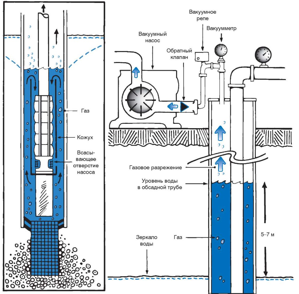
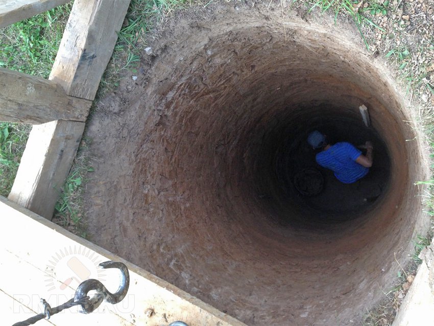
Trial exploration drilling is one of the most reliable ways to find water for a well.
Exploratory drilling allows not only to indicate the presence and level of occurrence of water, but also to determine the characteristics of the soil layers occurring before and after the aquifer
Drilling is carried out using a conventional garden hand drill. Since the depth of an exploratory well is on average 6-10 meters, it is necessary to provide for the possibility of increasing the length of its handle. To carry out the work, it is enough to use a drill with a screw diameter of 30 cm. As the drill deepens, so as not to break the tool, excavation must be carried out every 10-15 cm of the soil layer. Wet silvery sand can be observed already at a depth of about 2-3 meters.
The place for arranging the well should be located no closer than 25-30 meters from drainage trenches, compost and garbage heaps, as well as other sources of pollution. The most successful placement of the well is on an elevated site.
Terrain-following aquifers at elevated locations provide cleaner, filtered water
Rain water and melt water always flows from the hill to the valley, where it gradually drains into the water-resistant layer, which in turn displaces clean filtered water to the level of the aquifer.
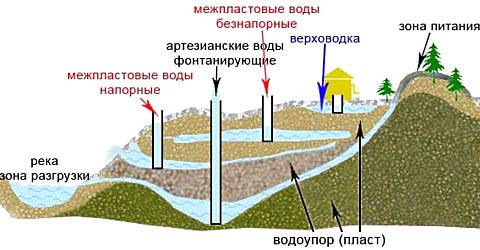
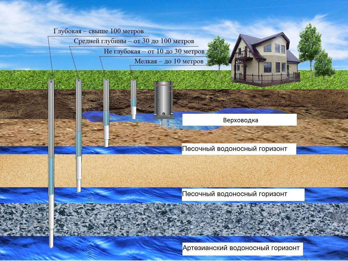
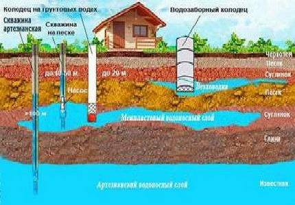
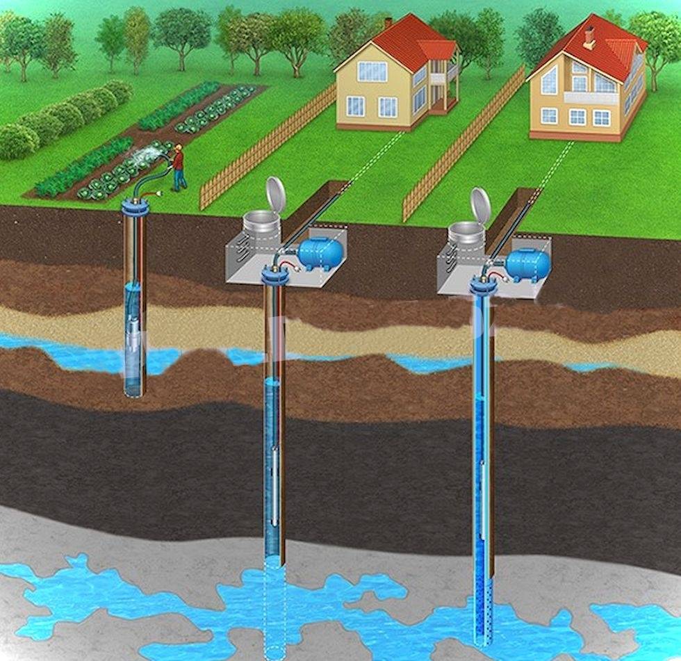
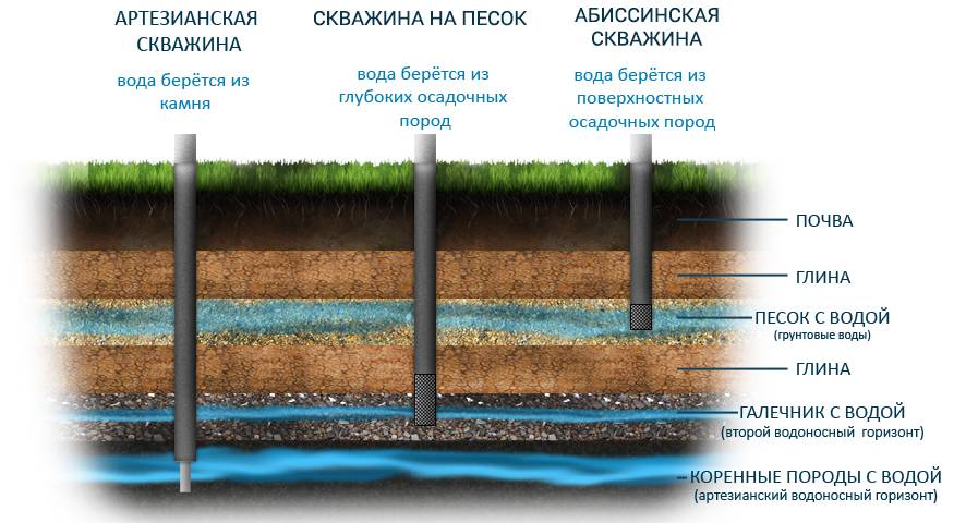
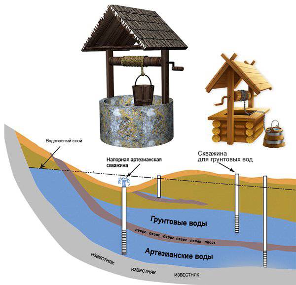
Types and functions of aquifers of the earth
There can be 2-3 aquifers on a land plot. These are loose rocks that can bind and hold water that appears during the period of precipitation and floods. The deeper the well, the better the water quality.
Types of groundwater:
- Soil - the first 4-6 m. This is the place where precipitation accumulates. Moisture comes from rain, floods, flood rivers.
- Ground - 9-18 m below ground level. Suitable for building a well.
- Interlayer - suitable for drilling wells. The depth of occurrence is from 20 to 50 m.
- Artesian - 40-200 m of occurrence. Guarantees crystal clear water, but this is not a suitable option for a well.
It is necessary to determine the aquifers of the earth in order to navigate the purity of the water. The shallow horizon is characterized by poor water conditions. It can get dirt, pesticides, bacteria. Such a liquid can only be used for technical purposes. To eat it, it is necessary to filter the water and boil it.


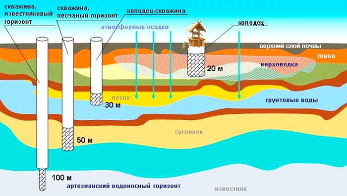
The first source of water can be found very close to the ground (2-2.5 m). From such a well, you can take water for household work. At the same time, even for such needs, it does not hurt to filter the liquid.
Effective ways to find water
There are more than a dozen ways to determine the proximity of water to the surface.The search for water under the well can be done using one of the following effective methods.
barometric method
A reading of 0.1 mm Hg of a barometer corresponds to a difference in pressure height of 1 meter. To work with the device, you must first measure its pressure readings on the shore of a nearby reservoir, and then move together with the device to the place of the proposed arrangement of the source of water production. At the well drilling site, air pressure measurements are taken again, and the water depth is calculated.
The presence and depth of groundwater is also successfully determined using a conventional aneroid barometer.
For example: the barometer reading on the river bank is 545.5 mm, and on the site - 545.1 mm. The level of groundwater occurrence is calculated according to the principle: 545.5-545.1 = 0.4 mm, i.e. the depth of the well will be at least 4 meters.
Exploration drilling
Trial exploration drilling is one of the most reliable ways to find water for a well.
Exploratory drilling allows not only to indicate the presence and level of occurrence of water, but also to determine the characteristics of the soil layers occurring before and after the aquifer
Drilling is carried out using a conventional garden hand drill. Since the depth of an exploratory well is on average 6-10 meters, it is necessary to provide for the possibility of increasing the length of its handle. To carry out the work, it is enough to use a drill with a screw diameter of 30 cm. As the drill deepens, so as not to break the tool, excavation must be carried out every 10-15 cm of the soil layer. Wet silvery sand can be observed already at a depth of about 2-3 meters.
The place for arranging the well should be located no closer than 25-30 meters from drainage trenches, compost and garbage heaps, as well as other sources of pollution. The most successful placement of the well is on an elevated site.
Terrain-following aquifers at elevated locations provide cleaner, filtered water
Rain water and melt water always flows from the hill to the valley, where it gradually drains into the water-resistant layer, which in turn displaces clean filtered water to the level of the aquifer.
Seismic exploration method
The search method is based on "tapping" the earth's crust with an energy device through the action of sound waves and capturing the response vibrations using a seismically sensitive device.
Depending on the structure and material of the layers of the earth's crust, waves pass through them differently, returning as damped reflected signals, the properties and strength of which are used to judge the rocks representing these layers, the voids and the presence of aquifers, and the accumulation of water between strong water-resistant layers. They take into account not only the strength of the returned oscillation, but also the time for which the wave comes back.
Testing is carried out at several points on the site, all indicators are entered into a computer and processed by a special program to determine the location of the water carrier.
Compare the obtained data collected in places with similar geology, in the immediate vicinity of water bodies, with data collected at the proposed drilling site.Or they find out the standard of the seismic signal, which is typical for most points of a particular place, and by the deviation from this standard, the supposed area of the aquifer occurrence is revealed. Artesian waters give a high seismic background, many times higher than the standard one.
Electrical sounding method
The method allows, with the help of instruments, to fix the presence of water in terms of the resistivity of the layers of the earth. Special probing equipment is used.
Four pipes-electrodes up to one and a half meters long are driven into the soil. Two of them are creating a field of electric voltage, and the other two are performing the role of testing devices.
They are sequentially bred to the sides. At the same time, the data are recorded, according to which the resistivity is measured, the potential difference is found out, thus consistently revealing indicators at different levels of the earth's crust.
Thus, electrical exploration finds out information that is inaccessible to the seismospectral method, being a less costly method of search.
The disadvantage of the method is that if the search area is enriched in fossil metals or is in proximity to railway lines, then sounding will become impossible.