- Professional Water Finding Methods
- Checking with a vine or electrodes
- Drill reconnaissance
- Effective ways to find water
- Search Practices
- Method # 1 - using glass containers
- Method # 2 - the use of hygroscopic material
- How to build an Abyssinian well
- How to find water for a well - an overview of methods and means
- Electrical sounding for finding water
- What is seismic exploration
- How to find water on the site using folk methods
- Using frames
- Vine use
- Effective ways to find water
- barometric method
- Exploration drilling
- Seismic exploration method
- Electrical sounding method
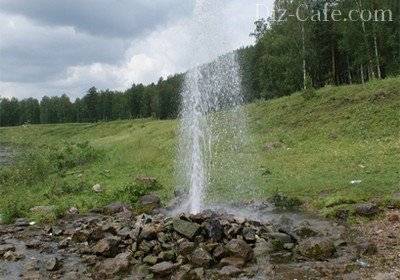
- At what depth should the aquifer be located?
- Water Search Techniques
- Inspection of the source at the neighbors
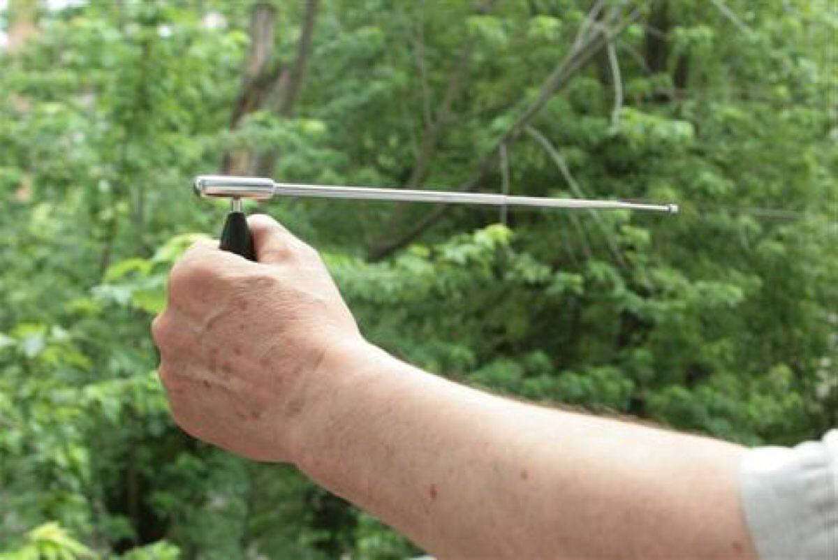
- Dowsing for water search
- Use of desiccants
- Exploring the landscape
- Observation of animals and insects
Professional Water Finding Methods
Checking with a vine or electrodes
Dowsing is considered a more professional way.
But not everyone manages to "make friends" with such a device.
Search order:
- First, two branches are found on the willow, coming out of the same trunk and located at an angle to each other.
- Cut off this "fork" and dry thoroughly.
- The finished frame is brought to the site, taken by the edges of the branches, spreading them about 150˚ so that the trunk looks up.
- With a vine, they slowly bypass the site.
- In places where there is an aquifer, the trunk will begin to lean towards the ground.
The frame gives the most accurate readings in the morning (from 6.00 to 7.00), after lunch (from 16.00 to 17.00) and in the evening (from 20.00 to 21.00).
The frame of the vine will begin to lean in a place where you feel high humidity.
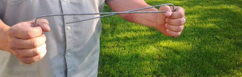
Devices from electrodes have a similar effect. 2 rods must be bent with the letter "G" and carried in the hands so that the free part is horizontal. In the place of the aquifer, the electrodes will begin to spin, cross.
The disadvantage of such a study is that the frames react not only to the deep layers, but also to the perch. They can also be “confusing” by laid underground communications.
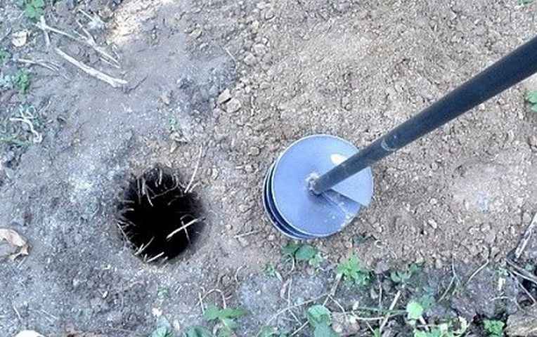
Drill reconnaissance
The most accurate of all methods is exploratory drilling. To do this, it is necessary to drill a well six or more meters deep into the earth with an ordinary garden drill. If you stumble upon a vein, do not rush to immediately dig a well. First, hand over the water for analysis to the sanitation station to make sure of its quality.
Only after positive results, proceed to dig the well.
Having drilled the earth in several places of the site, you will find the strongest aquifer
Combining several methods will increase your chances of finding the best water.
Having your own water source in a suburban area is often not a luxury, but a necessity.
. After all, there is no central water supply outside the city. And it is impossible to care for a garden and run a household without water.
Therefore, many owners of private houses decide to equip their own well.But first you need to find a place on the site that is rich in high-quality underground water. And only after that you can think about how to create.
Effective ways to find water
There are more than a dozen ways to determine the proximity of water to the surface. The search for water under the well can be done using one of the following effective methods.
To do this, the granules of the substance are carefully dried beforehand in the sun or in the oven and put into an unglazed clay pot. To determine the amount of moisture absorbed by the granules, the pot must be weighed before instillation. A pot of silica gel, wrapped in a non-woven material or dense fabric, is buried in the ground to a depth of about a meter at the site where the well is planned to be drilled. A day later, the pot with the contents can be dug up and weighed again: the heavier it is, the more moisture it has absorbed, which in turn indicates the presence of an aquifer nearby.

The use of silica gel, which belongs to the category of substances that have the ability to absorb moisture and retain it, will allow in just a couple of days to determine the most suitable place for drilling a well or arranging a well
In order to narrow down the search for water for a well, several of these clay containers can be used simultaneously. You can more accurately determine the optimal location for drilling by re-burying the silica gel pot.
A reading of 0.1 mm Hg of a barometer corresponds to a difference in pressure height of 1 meter. To work with the device, you must first measure its pressure readings on the shore of a nearby reservoir, and then move together with the device to the place of the proposed arrangement of the source of water production.At the well drilling site, air pressure measurements are taken again, and the water depth is calculated.

The presence and depth of groundwater is also successfully determined using a conventional aneroid barometer.
For example: the barometer reading on the river bank is 545.5 mm, and on the site - 545.1 mm. Level groundwater deposits calculated according to the principle: 545.5-545.1 \u003d 0.4 mm, i.e. the depth of the well will be at least 4 meters.


Trial exploration drilling is one of the most reliable ways to find water for a well.
Exploratory drilling allows not only to indicate the presence and level of occurrence of water, but also to determine the characteristics of the soil layers occurring before and after the aquifer
Drilling is carried out using a conventional garden hand drill. Since the depth of an exploratory well is on average 6-10 meters, it is necessary to provide for the possibility of increasing the length of its handle. To carry out the work, it is enough to use a drill with a screw diameter of 30 cm. As the drill deepens, so as not to break the tool, excavation must be carried out every 10-15 cm of the soil layer. Wet silvery sand can be observed already at a depth of about 2-3 meters.
The place for arranging the well should be located no closer than 25-30 meters from drainage trenches, compost and garbage heaps, as well as other sources of pollution. The most successful placement of the well is on an elevated site.
Terrain-following aquifers at elevated locations provide cleaner, filtered water
Rain water and melt water always flows from the hill to the valley, where it gradually drains into the water-resistant layer, which in turn displaces clean filtered water to the level of the aquifer.
Search Practices
When the observation stage is over, and the neighbor said that he had already bought the site with a well, it is time for a practical search for water layers using standard or non-standard methods.
Method # 1 - using glass containers
Finding the right amount of glass jars of the same size is not a problem for those who occasionally do home canning. If you don’t have cans, buy them, the summer resident will definitely need them sooner or later.
The contents of ordinary glass jars will eloquently tell you exactly where the aquifer can be located: look for a container with the highest concentration of condensate
Throughout the area, you need to dig glass jars of the same size with the bottom up to a depth of at least 5 cm. The duration of the experiment is a day. The next morning, before the sun rises, you can dig and turn the dishes.
We are interested in those banks in which there is condensate. It is more in banks located above aquifers.
Method # 2 - the use of hygroscopic material
It is known that salt is hygroscopic, that is, it is able to absorb moisture even from the air. The red brick crushed into powder has the same properties. Silica gel is another material that is perfect for our purposes.
To conduct the experiment, we will need several clay pots that are not glazed.Choose a day when there has not been rain for a long time and we expect that it will not be expected in the next day.
You need pots like this, not covered with glaze inside and out, because they “breathe” perfectly and are able to pass water vapor inside
We fill the material into pots and weigh the resulting "devices". It is better to number the pots, and write down the data obtained. We wrap each pot with non-woven material and bury it at a depth of half a meter in the ground in different places of the site.
A day later, we unearth the bookmarks and re-weigh. The heavier the pot has become along with its contents, the closer to the place of its laying is the aquifer.


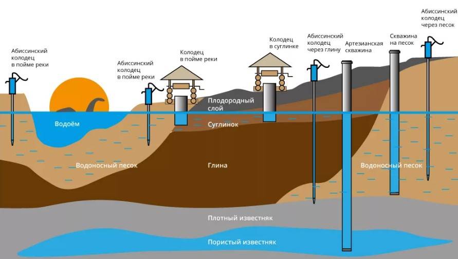
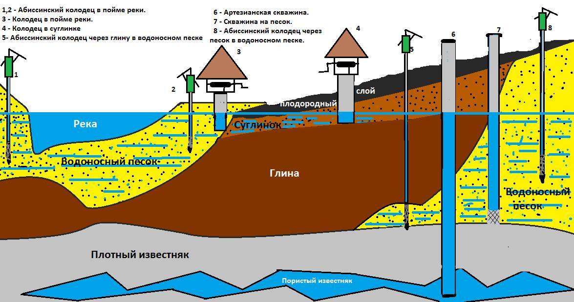
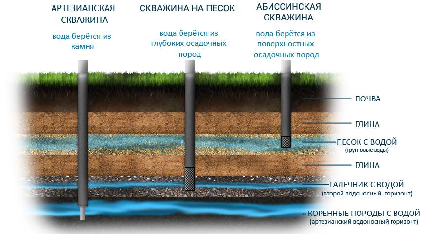
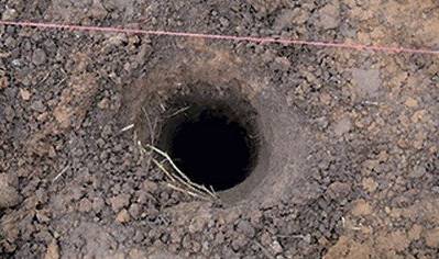
How to build an Abyssinian well
An Abyssinian well or Abyssinian well is a thin channel in the soil, for the arrangement of which the earth is pierced to a depth of 10 m. Further, this channel is formed using a pipe for a drinking well with a diameter of up to 1.5 inches. The well bottom is covered with marble chips. Due to the weak strength properties, a plastic pipe cannot be used to pierce the soil, therefore it is assigned an exclusively transporting function. Holes in the ground can be made with a garden drill, using collapsible rods to reach the aquifer.
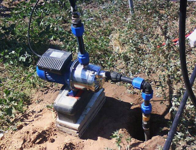
The pipe is cut into pieces 1-2 m long: with their help, a hole in the ground is equipped by building up
It is very important that the pipe joints were as reliable as possible in order to avoid damage to the structure.In order for the pipe to move along the channel without delay, a filter-needle is put on its tip (it will also help to purify the incoming water from all kinds of debris, and the source will thus not be flooded)
When water appears in the well, deepening work stops and the flushing process begins. As a rule, self-purification of water occurs during the day, after which it can be safely used for household and food purposes.
Abyssinian wells have the following advantages:
- Good service life.
- Ability to supply excellent quality water. A self-priming pump and a small cross section of the well make it difficult for various impurities, debris and bacteria to enter the well.
- Small capital investment in the arrangement.
How to find water for a well - an overview of methods and means
Attracting drillers to drill wells, the money will still have to be paid, even if there is no water. Therefore, before doing this, it would be best to try to find water in the area for the well on your own.
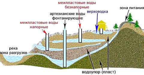
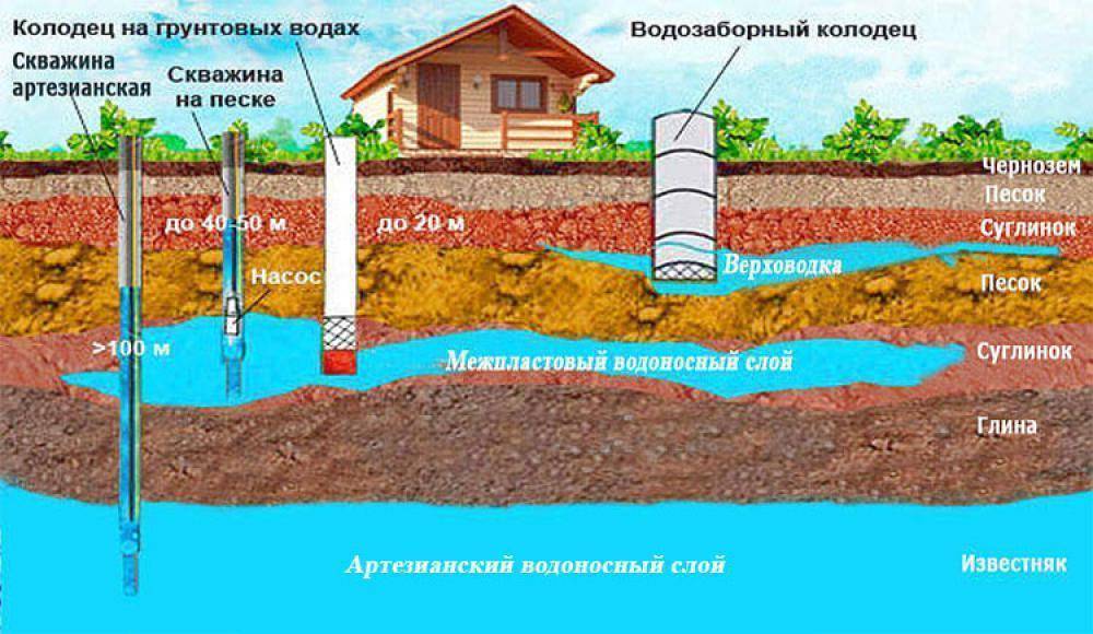
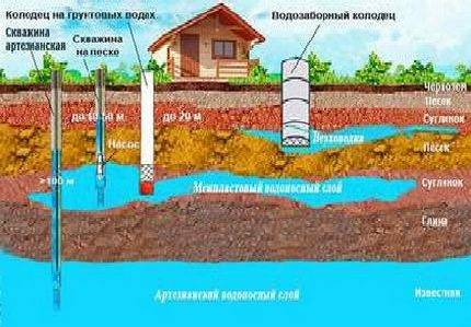
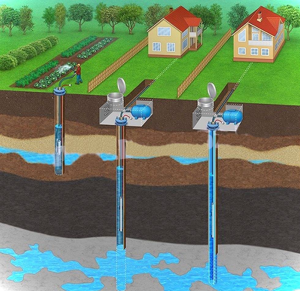
Depending on the depth of occurrence, groundwater is divided into three types:
- Verkhovodka - the depth of occurrence of high waters is not more than 5 meters from the surface of the earth. It is not recommended to drink such water, since most often it is formed due to precipitation;
- Groundwater - the depth of groundwater from 8 to 40 meters. As a result of being protected by soil, clay and rock, such waters most often serve as a source for a well and a well;
- Artesian - the depth of artesian waters, as a rule, is more than 40 meters.The main difference between artesian water is the presence of mineral salts in the composition and a fairly large flow rate of wells.
Now let's move on to the issues of finding water for a well on the site.
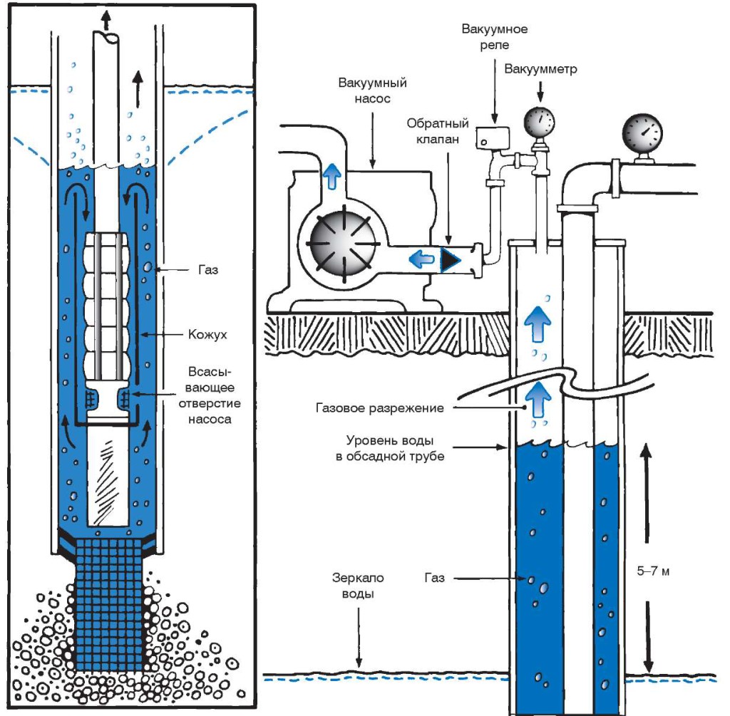
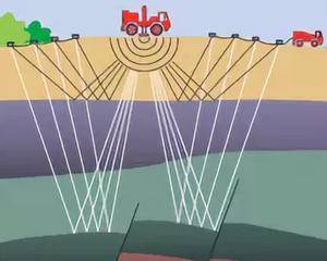
Electrical sounding for finding water
Let's start with modern methods of searching for water on the site, namely, with electrical sounding. The fact is that the specific electrical resistance of the aquifer and rocks has a difference. Soil saturated with water always has a lower electrical resistance.
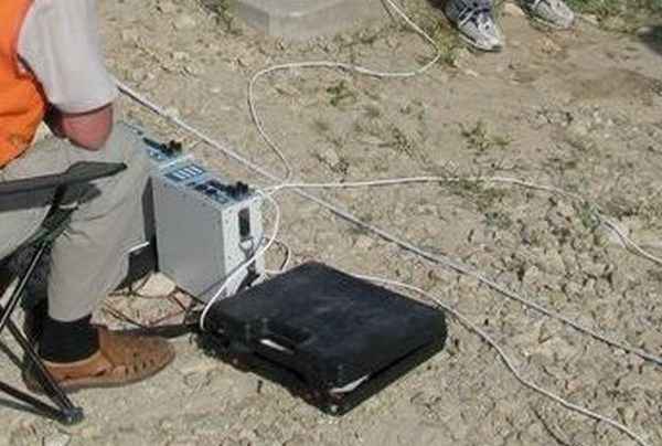
For vertical electrical sounding when searching for water, a low-frequency current is used. For these purposes, electrodes are clogged in different places of the site, to which an alternating voltage is applied. Then, electrical resistivity measurements are made. As mentioned above, in the presence of water, the resistance will always be less.
What is seismic exploration
Often, when searching for water for a well, a seismic survey method is also used, which is based on measuring the kinematics of waves. For these purposes, special instruments are used that make it possible to study the seismic background by directing the generated waves into the ground.
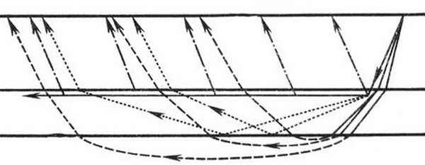
Upon reaching a layer of rock or water, the waves are reflected upward. In this way, the geology of the site can be more accurately explored and water can be found. Passing through water, the frequency of acoustic waves increases, which indicates the presence of a large accumulation of liquid in the soil.
How to find water on the site using folk methods
There are many ways to determine if there is water on the site. Here are some well-known methods.
Paying attention to plants
There are several types of plants that need water constantly and in large quantities.For example, wood lice, she is starfish. It is a small herb with large round leaves. Its accumulation is an accurate sign of water located close to the surface of the soil.


The same can be said about the accumulation of river gravel. A plant of the pink family is an excellent indicator. If you are faced with the task of how to find water on the site, then look for a cluster of plants. Under them there is necessarily an aquifer.
By the way, coniferous trees say otherwise. That is, there is water on the site, but it is very deep. Because the root system of pine and spruce are trunks directed in depth.
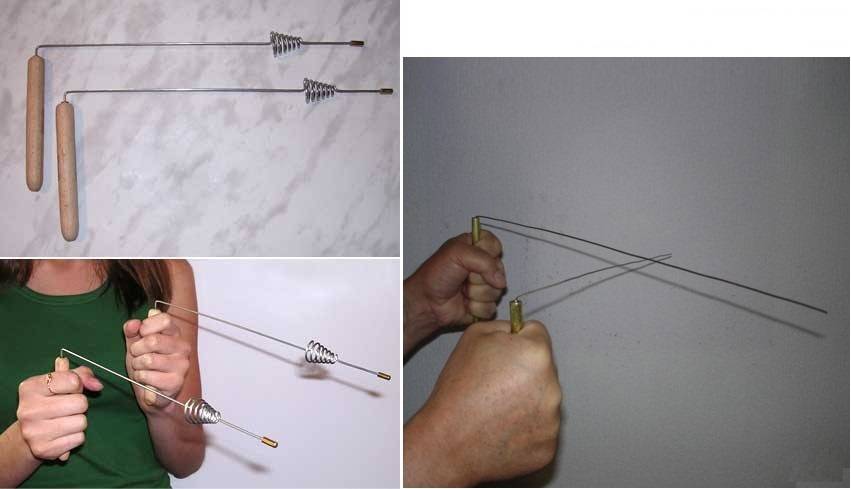
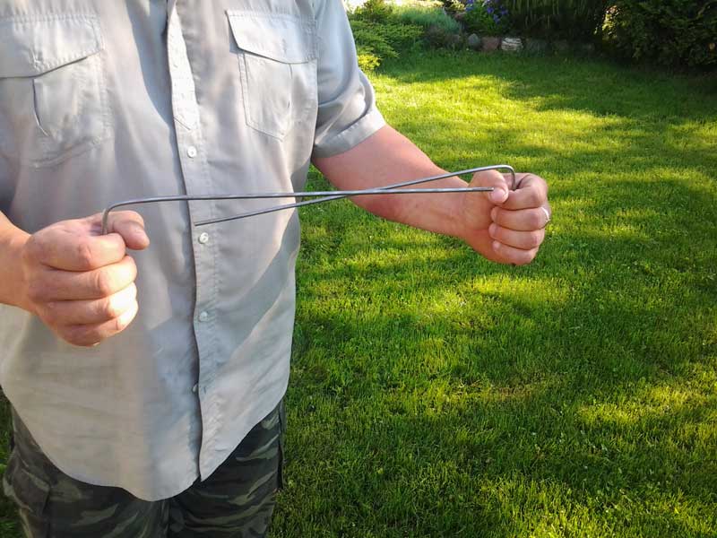
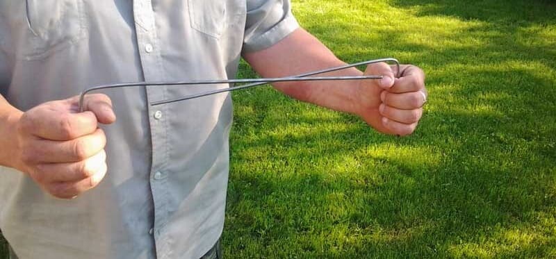
Using frames
This is the old fashioned way. To do this, you need an aluminum wire 40 cm long, the end of which is bent at a right angle. The length of the bend is 10 cm. It is it that is inserted into a wooden tube, which can be made from an elderberry sprig by selecting a core from it. The main requirement is that the aluminum wire must rotate freely inside the wooden tube. You need to make two such devices.
How to use aluminum frames:
- The cardinal points are determined in the area where the pegs are driven in.
- A frame is taken in each hand. The elbows are pressed to the body, the arms are bent at the elbows. Shoulders should be kept straight and parallel to the ground.
- Now in this position it is necessary to move from north to south, and then from east to west.
- Where the frames begin to rotate and cross, a peg is driven in.
There may be several such places, because a drain is a channel, like a river. Therefore, you can find a point convenient, for example, for the construction of a well or well.
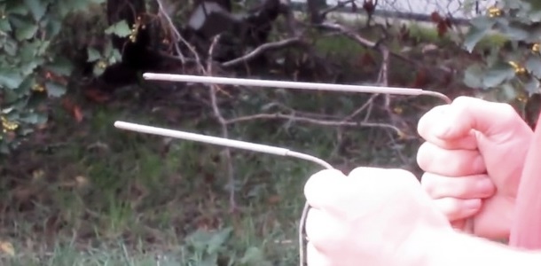
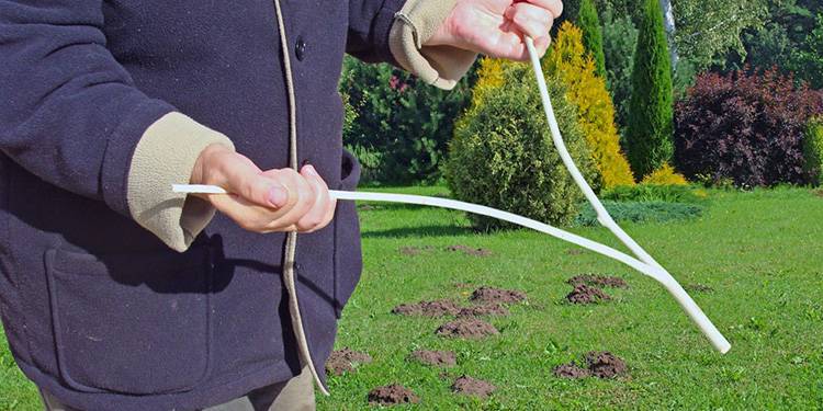
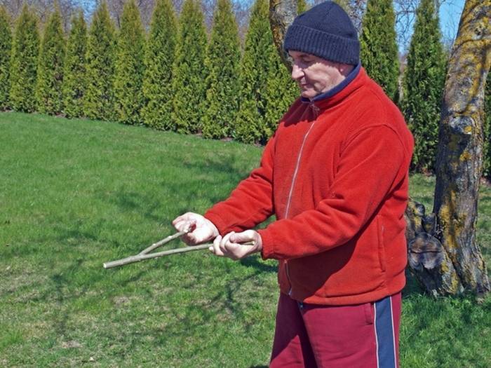
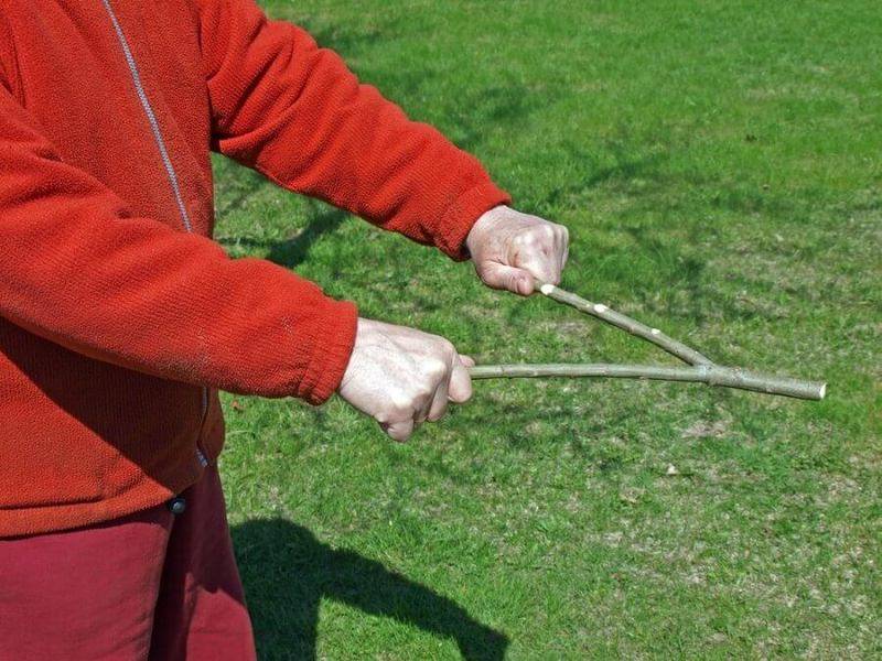
Vine use
Another old way to find water for a well.It has a scientific name - dowsing. Although scientists have not found scientific confirmation in it. Usually this method is used by people who are sensitive to signals coming from the ground. The most important thing is the correct interpretation of these signals. After all, communications are often located underground, which also emit signals
And here it is important not to run into, for example, a pipe, thinking that they attacked the aquifer
As practice shows, this method gives 50% success. That is, it is not so accurate, but it all depends on the person, his abilities. And if the water is deep, then it is difficult to find it with a vine. How they look for water with a vine. To do this, you need a fresh branch of a tree, usually willow is chosen. It should be in the shape of a slingshot. As for the sizes:
- diameter 8-12 mm;
- the distance between the ends of the slingshot is the width of the torso of the person who holds it in his hands.
How vines work:
- She is held in her hands, squeezing lightly in her fists by the horns.
- The end of the slingshot is directed away from the person, preferably horizontally, so the vine itself should be light.
- The person moves around freely.
- As soon as the device deviates from the horizontal up or down a few centimeters, this means that there is water below the ground.
So, three ways were dismantled on how to find water on the site with your own hands, using folk remedies. Now we will consider aquifer characteristics. But let's give you one more piece of advice.
If there are already neighbors near the suburban area who operate a well or a well, then you need to talk to them like a neighbor. They will tell you exactly at what depth the groundwater level is located, whether it is enough to operate a hydraulic structure, and what is better to do: a well or a well.
Effective ways to find water
There are more than a dozen ways to determine the proximity of water to the surface. The search for water under the well can be done using one of the following effective methods.
barometric method
A reading of 0.1 mm Hg of a barometer corresponds to a difference in pressure height of 1 meter. To work with the device, you must first measure its pressure readings on the shore of a nearby reservoir, and then move together with the device to the place of the proposed arrangement of the source of water production. At the well drilling site, air pressure measurements are taken again, and the water depth is calculated.
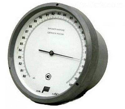
The presence and depth of groundwater is also successfully determined using a conventional aneroid barometer.
For example: the barometer reading on the river bank is 545.5 mm, and on the site - 545.1 mm. The level of groundwater occurrence is calculated according to the principle: 545.5-545.1 = 0.4 mm, i.e. the depth of the well will be at least 4 meters.


Exploration drilling
Trial exploration drilling is one of the most reliable ways to find water for a well.
Exploratory drilling allows not only to indicate the presence and level of occurrence of water, but also to determine the characteristics of the soil layers occurring before and after the aquifer
Drilling is carried out using a conventional garden hand drill. Since the depth of an exploratory well is on average 6-10 meters, it is necessary to provide for the possibility of increasing the length of its handle. To carry out the work, it is enough to use a drill with a screw diameter of 30 cm.As the drill deepens, so as not to break the tool, excavation must be carried out every 10-15 cm of the soil layer. Wet silvery sand can be observed already at a depth of about 2-3 meters.
The place for arranging the well should be located no closer than 25-30 meters from drainage trenches, compost and garbage heaps, as well as other sources of pollution. The most successful placement of the well is on an elevated site.
Terrain-following aquifers at elevated locations provide cleaner, filtered water
Rain water and melt water always flows from the hill to the valley, where it gradually drains into the water-resistant layer, which in turn displaces clean filtered water to the level of the aquifer.
Seismic exploration method
The search method is based on "tapping" the earth's crust with an energy device through the action of sound waves and capturing the response vibrations using a seismically sensitive device.
Depending on the structure and material of the layers of the earth's crust, waves pass through them differently, returning as damped reflected signals, the properties and strength of which are used to judge the rocks representing these layers, the voids and the presence of aquifers, and the accumulation of water between strong water-resistant layers. They take into account not only the strength of the returned oscillation, but also the time for which the wave comes back.
Testing is carried out at several points on the site, all indicators are entered into a computer and processed by a special program to determine the location of the water carrier.
Compare the obtained data collected in places with similar geology, in the immediate vicinity of water bodies, with data collected at the proposed drilling site. Or they find out the standard of the seismic signal, which is typical for most points of a particular place, and by the deviation from this standard, the supposed area of the aquifer occurrence is revealed. Artesian waters give a high seismic background, many times higher than the standard one.
Electrical sounding method
The method allows, with the help of instruments, to fix the presence of water in terms of the resistivity of the layers of the earth. Special probing equipment is used.
Four pipes-electrodes up to one and a half meters long are driven into the soil. Two of them are creating a field of electric voltage, and the other two are performing the role of testing devices.
They are sequentially bred to the sides. At the same time, the data are recorded, according to which the resistivity is measured, the potential difference is found out, thus consistently revealing indicators at different levels of the earth's crust.
Thus, electrical exploration finds out information that is inaccessible to the seismospectral method, being a less costly method of search.
The disadvantage of the method is that if the search area is enriched in fossil metals or is in proximity to railway lines, then sounding will become impossible.
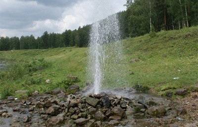
At what depth should the aquifer be located?
The water in the ground is kept by water-resistant layers, which prevent the veins from breaking through to the ground or going too deep. Such layers, as a rule, consist of clay, but there are also stone ones.
Between them is an aquifer of sand, saturated with clean water, which must be sought. Since the water-resistant layers are not located strictly horizontally, but with all kinds of bends, niches with a high level of humidity are formed in places of curvature, which are called underground lakes.


Several aquifers can lie in the ground, but the best are those located below 15 m in depth.
When looking for water for a well, you can get to the lake, which is very close to the surface - only 2.5 m deep. The water in it is called perched, because it is replenished with precipitation, melting snow, carrying with it dirt and a lot of harmful substances. Such an aquifer for a well is not suitable both in terms of the quality of the liquid and in terms of quantity. In a drought, your well will simply dry up, because the underground lake with perched water holds a small amount of water, and if it is a hot summer, it will leave it altogether and will not return until late autumn.
For a well, water is needed from lakes that are located about 15 m deep into the earth. There are aquifers of continental sands, the thickness of which is so great that it can feed a huge amount of cubic meters of water. And these sands serve as excellent filters, thanks to which the water is maximally purified from impurities and debris and becomes drinkable.
Water Search Techniques
Inspection of the source at the neighbors
- Well depth.
- The height of the water column.
- level constancy. If it changes periodically, you need to dig deeper.
- Barrel design and type. Build your well taking into account the experience of performing work in the area.
Dowsing for water search
- Cut 2 pieces of wire 400mm long.
- Bend 100 mm of each piece strictly at right angles.
- Pick 2 sprigs of elderberry, remove the core and insert the short side of the wire inside.
- Take a wired elderberry branch in each hand. Press your elbows to the body. The wires should be like a continuation of the hands.
- Holding them lightly, effortlessly, walk first from north to south, and then from east to west. If the rods turned in one direction, then there is an aquifer.
- Above the watercourse, the frames will begin to move and intersect, leave a mark in this place on the ground. After passing the fault, the elements will turn in opposite directions. Walk over the mark again, but in a perpendicular direction. If the wires cross again, there is a high probability that an aquifer is underground.
When using dowsing, consider the following points:
- The movement of the vine does not necessarily indicate the presence of water at a given location. There may be a junction of various soils underground, or a large diameter pipe has been laid in this place. Many errors occur near populated areas, where there are numerous underground utilities.
- The frame does not respond to a large aquifer evenly distributed over the area.
- The presence of water in the area must be confirmed by other dowsers. If their conclusions are contradictory, digging a well is not recommended.
- The reliability of the method is only 50%.
Use of desiccants
Perform the following operations:
- Dry the indicator in the oven.
- Pour 1 liter of loose mass into a pot.
- Weigh the container and record the result.
- Wrap it in a thick cloth and bury it in the ground in the place of interest to you.
- Dig up in a day and weigh the pot again.
- Determine how much the mass of the container has increased.
- Repeat the procedure on the other area.
- Compare the change in the weight of the indicator in different places. Where the mass of silica gel has increased more, the water is located closer to the surface.
Exploring the landscape
Pay attention to such points:
At higher elevations, aquifers are very deep.
Do not look for veins near natural lakes and quarries.
There will also not be a positive result near large plantings of acacias and beech.
The desired areas can be identified in the summer at dawn by the fog that gathers over the place of interest to us. The denser the atmospheric phenomenon, the less you have to dig.
Sedge, flush, coltsfoot, alder always grow above aquifers.
A good sign of the proximity of the liquid are birches. On wet ground, they look unsightly - low, twisted, with a knotty trunk.
If the trunks of alder, willow and birch are strongly inclined to one side, then that is where the moisture is close to the surface.
The presence of thickets of nettle, sorrel, hemlock on the site indicates wet soil.
A pine or spruce grove suggests the opposite - the layer of interest to us lies very far from the surface.
Some plants determine how deep the water is, but they must be wild and grow in large groups.
Pay attention to the thickets of blackberries, bird cherry, lingonberries and buckthorn.
Observation of animals and insects
- Small field rodents do not build nests in places where they can be flooded. In such cases, they settle on a hill or in trees.
- In extreme heat, the horse begins to beat the ground with his hoof over the place where the level of humidity is maximum.
- Dogs burrow into slightly wet ground in the summer.
- The hen will not make a nest on the ground with high humidity.
- The goose, on the other hand, builds its nest above the spring.
- Midges accumulate in large numbers where there is evaporation.